
Gabrielle, which on Sunday became only the second hurricane to form in 2025 so far, strengthened into a major hurricane early Monday, packing maximum sustained winds of 120 mph, the National Hurricane Center said. Meanwhile, two more tropical hotspots east of the Caribbean Sea were drawing the attention of forecasters.
Texas, during this Atlantic hurricane season that began on June 1, has not seen a direct landfall from a tropical cyclone this summer. Furthermore, as we get deeper into the fall season, weather history tells us that the chances of a tropical storm or hurricane coming ashore on the Texas Gulf Coast get lower and lower. Could these emerging tropical systems that are approaching the Caribbean ever enter the Gulf of Mexico? Here’s what forecasters are saying:
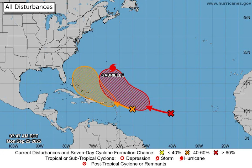
Where is Gabrielle now?
Gabrielle, which had been a tropical storm since the middle of last week, was as of 8 a.m. Monday a Category 3 hurricane, the hurricane center said. Its rotating center was about 195 miles southeast of Bermuda, moving north at 10 mph.
Gabrielle was projected to head north then sharply turn northeast out to sea in the North Atlantic before eventually approaching the Azores, about 1,000 miles offshore from southwestern Europe. (Geostationary Operational Environmental Satellites/CIRA and NOAA)
“This general motion is expected today, followed by a faster northeastward or east-northeastward motion on Tuesday,” the hurricane center said in a bulletin Monday. “On the forecast track, the center of Gabrielle is expected to pass east of Bermuda tonight.”
Forecasters said Gabrielle was likely to weaken soon as it drifts farther into the cooler northern latitudes of the North Atlantic later this week.
Gabrielle appears to be yet another tropical cyclone this hurricane season whose path has been influenced by the Bermuda High, a semi-permanent system of high atmospheric pressure over the mid-Atlantic. Depending on the Bermuda High’s position further east or further west, its clockwise circulation of air flow tends to either push tropical cyclones into the Gulf of Mexico or the Caribbean, or it redirects them north and east into the open waters of the Atlantic.
2 more tropical hotspots
Two tropical systems emerging in the warmer Atlantic waters just east of the Caribbean Sea are being watched for potential development this week by the National Hurricane Center on Monday.
Low atmospheric pressure in the tropics can, under the right conditions, can produce thunderstorms that organize around a strong counterclockwise rotating center and become a tropical cyclone. Depending on the wind speeds generated by the storms, the cyclone can be classified as a tropical depression (winds as strong as 38 mph), a tropical storm (winds of 39 to 73 mph), or a hurricane (winds of 74 mph or stronger).
A tropical wave of low pressure was churning in the central Atlantic, about midway between the Lesser Antilles on the eastern edge of the Caribbean and the Cabo Verde Islands about 500 miles from the westernmost coastlines of West Africa. Forecasters were giving this system a 70% chance of development in the next seven days.
Two tropical systems emerging in the warmer Atlantic waters east of the Caribbean Sea are being watched for potential development this week by the National Hurricane Center on Monday. (National Hurricane Center)
More thunderstorm activity was occurring in this system Monday, and “environmental conditions are forecast to become more favorable for development by tomorrow,” the hurricane center said. “A tropical depression is likely to form by the middle to latter part of this week while while the system moves west-northwestward to northwestward across the central Atlantic.”
Closer to the Caribbean, about 400 miles east of the Leeward Islands, another tropical wave that also was producing more thunderstorms Monday, had a 40% chance of developing into a tropical cyclone.
“Environmental conditions appear marginally conducive for slow development over the next few days as the wave moves quickly westward to west-northwestward at 15 to 20 mph,” hurricane center forecasters said. “By the latter part of this week, the system is expected to slow down and turn more northwestward, and a tropical depression could form late this week when the system is over the southwestern Atlantic Ocean or near the Bahamas.”