
- S-L-O-W cooldown heading into the holiday weekend
- Tracking daily thunderstorm chance along/east of Cascades
- Small chance for a valley storm or two Saturday
Don’t forget to download our FOX 12 Weather App to stay ahead of the forecast! Get real-time radar, updates from our team, and exclusive content right at your fingertips.
STAYING HUMID…
Clouds stuck around and acted like a “blanket” overnight, especially in the central valleys! Portland is expected to beat the record warm low for the date. Salem though, ended up with a morning low of 73°! If we don’t get any cooler before midnight, this will be the SECOND WARMEST NIGHT ever recorded at the Salem Airport.
Hazy sunshine has stuck around for most of the day. Despite the upper-level clouds, we are still getting into the low 90s!
We’ve been tracking scattered thunderstorms along and east of the Cascades this afternoon. I don’t anticipate any storms turning severe, but expect isolated gusty wind and abundant lightning through the evening.
A few storms passed through the central valley earlier today around Salem/Mcminnville. That shouldn’t happen again, but with such a humid and moist atmosphere, we can’t rule anything out!
We got another WARM night on tap with lows in the upper 60s. It will be uncomfortable for those without air conditioning.
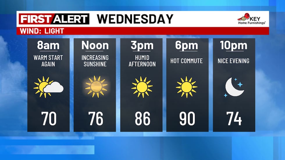
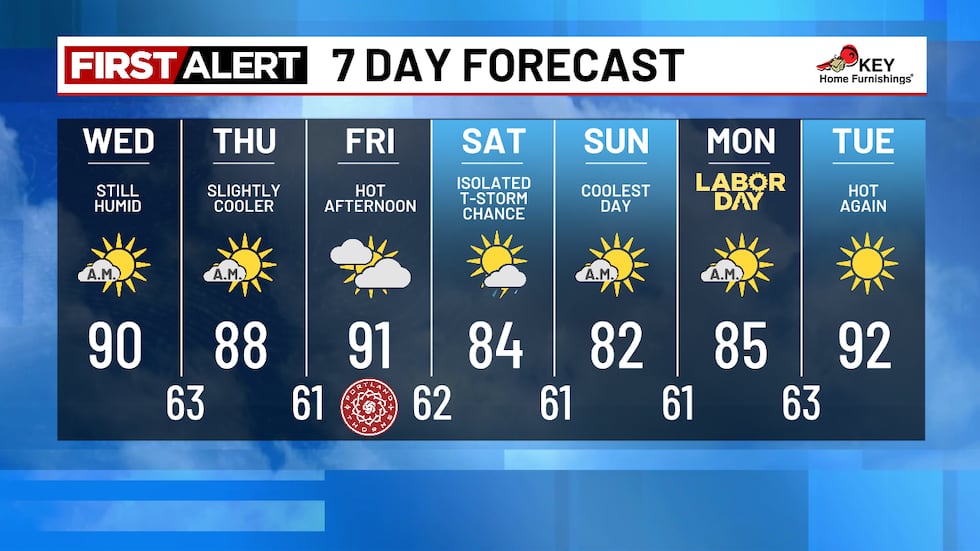
WEDNESDAY: A stray shower is possible early tomorrow morning, but the clouds will clear in the afternoon. Lingering wildfire smoke will still create a “hazy” look. Sadly, we aren’t going to get rid of the humidity either. Highs will be in the upper 80s and low 90s.
Areas along and east of the Cascades should expect isolated to scattered thunderstorms tomorrow.
THURSDAY + FRIDAY: The weather pattern through Labor Day Weekend features weather systems remaining away from the region and warmer than normal temperatures for late August and early September. Expect lots of afternoon sunshine the rest of the workweek with highs in the upper 80s and low 90s. Lows will be in the low 60s.
🏝️LABOR DAY FORECAST
Got plans this holiday weekend? The weather is looking great! A weak disturbance passes to the northwest, which brings a southwesterly flow to the region. Paired with hot and humid air, we could see a storm or two pop-up on Saturday. This won’t impact everybody.
Temperatures will decrease a little compared to previous days. Highs will be in the 80s through Labor Day Monday. Not too bad as we wrap up the unofficial last weekend of summer!
NEXT WEEK: Things are heating up again next week… We’ll be in the low 90s again by next Tuesday.
Copyright 2025 KPTV-KPDX. All rights reserved.