Pittsburgh: Isolated showers today
A front pushes through today with limited shower coverage.
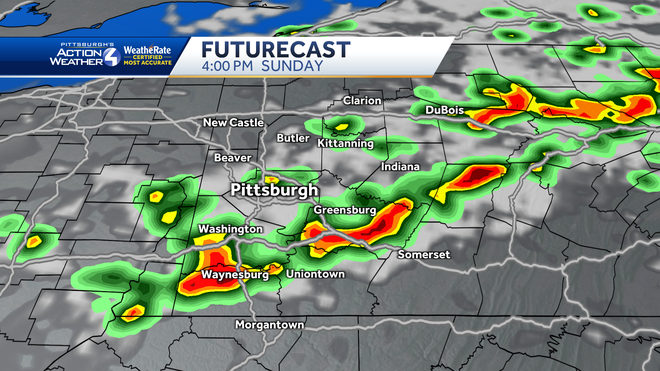
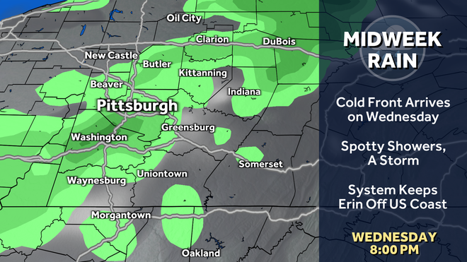
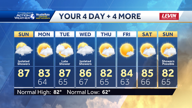
SPORTS. CERTAINLY DIDN’T FEEL LIKE FOOTBALL WEATHER OUT THERE. NO REAL FOOTBALL WEATHER IN SIGHT JUST YET. NO TONING DOWN THE 90S, BUT STILL THE WARM TEMPERATURES, HUMIDITY STICKING AROUND AS WE ENTER A BRAND NEW WEEK. ALSO BRINGING IN SOME SUMMER SHOWERS TODAY. OF COURSE, RAIN’S BEEN HARD TO COME BY HERE IN THE MONTH OF AUGUST, SO EVEN THOUGH YOU MAY HAVE TO DODGE SOME RAIN FROM TIME TO TIME, TODAY CERTAINLY WELCOMED ACROSS WESTERN PENNSYLVANIA. NO SHOWERS TOMORROW. SOME LATE DAY ACTIVITY POSSIBLE ON TUESDAY. MAKE IT A LITTLE BIT WETTER AS WE APPROACH WEDNESDAY. BUT AT THIS POINT THE RAIN AND STORMS HAVE BEEN TRACKING REALLY THROUGH THE BULK OF THE MORNING. NOW STARTING TO BREAK DOWN. STILL A LITTLE BIT BUSIER BETWEEN NEW CASTLE AND ELLWOOD CITY, SPILLING OVER AROUND PROSPECT. EVEN MCCONNELLS MILL AS WE LOOK INTO NORTHWESTERN BUTLER COUNTY. THAT’S ALSO IMPACTING THE LAKE ARTHUR AREA. SKIRTING JUST SOUTH OF SLIPPERY ROCK, RIMERSBURG A DECENT DOWNPOUR THERE. ALL OF THAT IS WORKING FROM WEST TO EAST. THE RAIN ALSO STARTING TO SETTLE DOWN JUST OUTSIDE OF BUTLER. THIS IS NOW AROUND SAXONBURG TRYING TO TRACK CLOSER TO SARVER, ALSO AROUND KITTANNING AT THIS POINT, AND THE RAIN IS BASICALLY ALL DRIED UP BEFORE IT EVEN MADE IT INTO ALLEGHENY COUNTY. SO CERTAINLY A GOOD TREND THERE. EVERYBODY ELSE IS QUIET. WE WILL STAY DRY HERE FOR A COUPLE MORE HOURS, BUT THERE IS A COOL FRONT THAT’S APPROACHING THAT WILL STILL PRODUCE SOME ISOLATED SHOWERS, ESPECIALLY AS WE GO INTO THE AFTERNOON AGAIN ON THE RADAR. EVERYTHING’S BEEN NORTH OF PITTSBURGH. FOCUS IS MORE GOING TO SHIFT SOUTH INTO THE AFTERNOON AS WE BUILD UP MORE STEAM. THAT CREATES REALLY A FAVORABLE ENVIRONMENT FOR POTENTIALLY MORE DOWNPOURS, POSSIBLY EVEN A FEW NON-SEVERE THUNDERSTORMS. SO THOSE RAINFALL TOTALS CERTAINLY JUMPING OUT, ESPECIALLY AROUND GREENSBURG, EVEN WAYNESBURG, AS WE GO THROUGH THIS AFTERNOON WITH MORE OF THAT LOCALLY HEAVY RAIN, WE’LL TONE DOWN THE HEAT AND HUMIDITY JUST A TOUCH TOMORROW 83. MEANWHILE, WE’RE BACK CLOSER TO 90 ON TUESDAY. IT’S DRY UNTIL LATE IN THE DAY. IT DOES LOOK LIKE WEDNESDAY WILL BE THE BETTER OF THE TWO MIDDLE DAYS OF THIS UPCOMING WEEK. HERE’S FUTURECAST AGAIN. YOU CAN SEE THINGS ARE CALMING DOWN FOR THE NEXT FEW HOURS, BUT AS WE APPROACH, LET’S SAY 1:00 2:00 THIS AFTERNOON, A FEW MORE OF THOSE SHOWERS START TO BUBBLE UP. KEEP IN MIND THESE AREAS HAVE ALREADY SEEN RAIN TODAY, SO MORE THAN LIKELY JUST A SOFT SHOWER COMING THROUGH. BUT AS THAT ACTION CONTINUES TO WORK TOWARDS THE SOUTH AND EAST, IMPACTING, LET’S SAY ALLEGHENY, WASHINGTON, WESTMORELAND COUNTIES, CERTAINLY SOUTH OF I-70 AS WELL, YOU HAVE THE POTENTIAL TO SEE A FEW MORE DOWNPOURS EVEN HERE, A LITTLE BIT MORE THUNDER AND LIGHTNING AS WE CONTINUE ON THROUGH THE LATE AFTERNOON, EARLY PARTS OF THE EVENING. BASICALLY, EVERYTHING SETTLES SOUTH AS WE GET CLOSER TO DINNERTIME THIS EVENING AND THINGS WILL STAY QUIET. THEN FOR ABOUT 24, EVEN 48 HOURS AGAIN, WEDNESDAY DOES LOOK TO BE THE WETTER DAY AS WE APPROACH THE MIDDLE PART OF THE WEEK. THAT WILL BE WITH THE COLD FRONT. THAT WILL KICK OFF MORE SPOTTY SHOWERS, POSSIBLY AN EMBEDDED THUNDERSTORM TOO. NOT OVERLY CONCERNED ABOUT THE HEAVY RAIN THREAT NOW, SO KEEP THOSE IMPACT DAYS AT BAY. BUT THIS SYSTEM WILL PUSH HURRICANE ERIN FARTHER AWAY FROM THE EAST COAST. NO IMPACTS TO THE MAINLAND OF THE US, BUT CERTAINLY SOME ROUGH WAVES ACROSS SOME COASTAL AREAS. THOUGH AS WE CONTINUE ON WITH YOUR 4-DAY PLUS 4 MORE FORECAST HERE, CLOSER TO HOME TEMPERATURES LOW TO MID 80S AS WE CONTINUE THROUGH NEXT WEEK. SO EVEN THOUGH DOZENS OF DISTRICTS GO BACK TO SCHOOL THIS WEEK, STILL PLENTY OF TIME TO GET OUTSIDE, RUN AROUND AFTER SCHOOL LATER IN THE WEEK AS WE WILL KEEP IT DRY THROUGH AT LEAST SATURDAY AND A NICE CHANGE OF PACE AS STUDENTS AND TEACHERS ARE HEADING BACK INTO THE CLASSROOM. IT WON’T BE TOO HOT. STILL HOT, BUT NOT TOO NICE. LITTLE TRANSITION FROM SUMMER TO BACK TO SCHOOL TI
Pittsburgh: Isolated showers today
A front pushes through today with limited shower coverage.
Updated: 10:20 AM EDT Aug 17, 2025
Editorial Standards
The latest dry stretch ends today with isolated showers. Most of your outdoor weekend plans should be fine. A couple batches of showers return mid-week.Isolated showers today”Isolated” is the key word in today’s forecast. Parts of western Pennsylvania won’t see much rain at all. Areas near and north of US-422 caught the rain this morning. Dry time will extend into the early afternoon hours.A front is on the way and will usher in additional isolated showers with embedded storms during the heat of the day. No strong storms are expected; however, downpours are possible. Pittsburgh and locations to the south will get the dose of heavy rain this go-around. The radar will settle down by dinnertime.More showers mid-weekThe new week begins on a quiet note with a drop in temperature and humidity. A stalled boundary will wobble toward Western PA and push more showers and storms our way Tuesday and Wednesday. Neither day will be a washout. Any showers on Tuesday will likely hold off until late in the day. Wednesday appears to be the wetter day as a cold front swings through the area. Locally heavy rain is possible again.Comfortable summer daysThis week won’t be too unbearable when it comes to the heat. This afternoon’s highs will reach the upper 80s again. Tuesday and Wednesday will be warmer too. But, behind the mid-week front more seasonal, less humid air will settle in. The “pleasant” feeling should linger into the start of next weekend.SUNDAY: Sun and clouds with isolated showers, especially this afternoon. Humid, high: 87°.TONIGHT: Showers end early, some clearing with patchy fog. Low: 64°.MONDAY: Partly cloudy and not as hot. High: 83°, low: 65°.TUESDAY: Sun and clouds with a late-day shower chance. High: 87°, low: 67°.
The latest dry stretch ends today with isolated showers. Most of your outdoor weekend plans should be fine. A couple batches of showers return mid-week.
Isolated showers today
“Isolated” is the key word in today’s forecast. Parts of western Pennsylvania won’t see much rain at all. Areas near and north of US-422 caught the rain this morning. Dry time will extend into the early afternoon hours.
A front is on the way and will usher in additional isolated showers with embedded storms during the heat of the day. No strong storms are expected; however, downpours are possible. Pittsburgh and locations to the south will get the dose of heavy rain this go-around. The radar will settle down by dinnertime.
More showers mid-week
The new week begins on a quiet note with a drop in temperature and humidity. A stalled boundary will wobble toward Western PA and push more showers and storms our way Tuesday and Wednesday. Neither day will be a washout. Any showers on Tuesday will likely hold off until late in the day. Wednesday appears to be the wetter day as a cold front swings through the area. Locally heavy rain is possible again.
Comfortable summer days
This week won’t be too unbearable when it comes to the heat. This afternoon’s highs will reach the upper 80s again. Tuesday and Wednesday will be warmer too. But, behind the mid-week front more seasonal, less humid air will settle in. The “pleasant” feeling should linger into the start of next weekend.
SUNDAY: Sun and clouds with isolated showers, especially this afternoon. Humid, high: 87°.
TONIGHT: Showers end early, some clearing with patchy fog. Low: 64°.
MONDAY: Partly cloudy and not as hot. High: 83°, low: 65°.
TUESDAY: Sun and clouds with a late-day shower chance. High: 87°, low: 67°.


