
Feels-Like Temps Up To 115 Degrees Possible
Another heat dome of high pressure is spreading dangerously hot temperatures and high humidity from the South into parts of the Midwest this week, and it could have real staying power for some. While the Northeast will see a reprieve from summer’s searing temperatures over the next few days, increasingly hot and muggy air will make at least a brief return by late week.
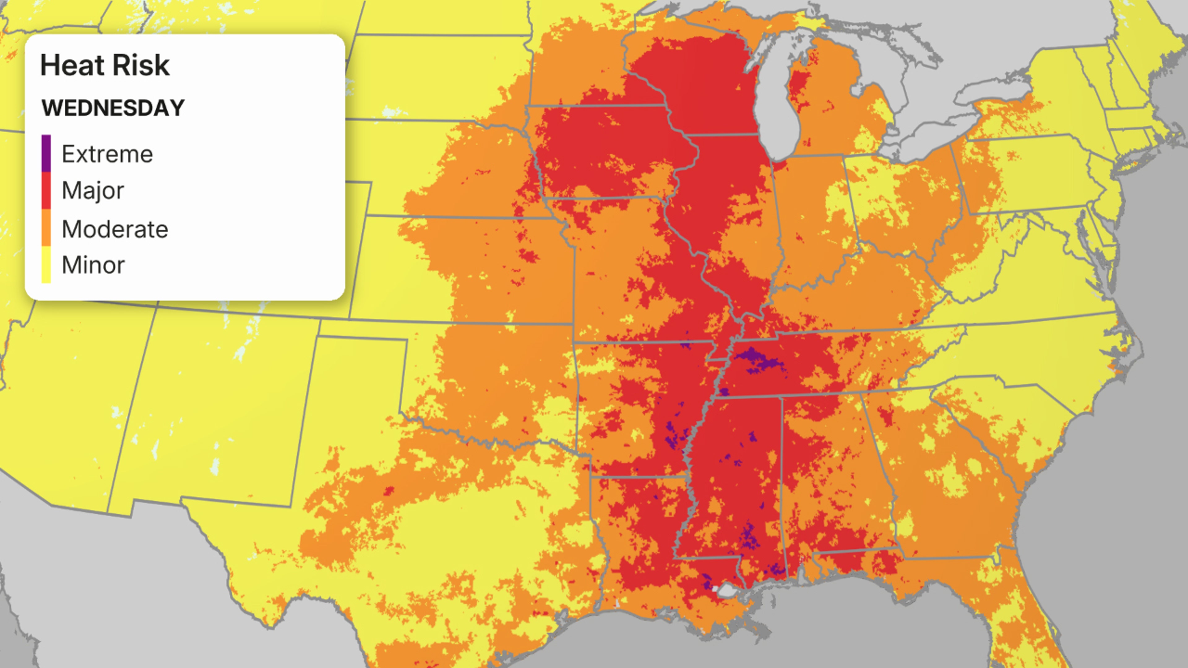
The National Weather Service has issued extreme heat warnings and watches and heat advisories for millions across the South, Plains and Midwest. Expect these alerts to shift around with the heat dome through the week.
Heat Alerts
Here are the main takeaways from the forecast:
Weather in your inbox
(TRACK THE HEAT: Temperatures | Heat Index)
Where And When Will It Arrive?
– Beginning Tuesday, hotter, more humid air will spread into parts of the Midwest, especially the Ohio Valley, but also parts of the Great Lakes. A cold front will knock temperatures down a bit in the upper Midwest and Great Lakes late week, but it appears over the weekend the heat dome will build back northward in these areas.
– At least somewhat hot and humid air will also stretch into parts of the Northeast as soon as Wednesday and especially Thursday. Hot conditions will then peak around Friday in the Northeast, lingering into Saturday for some.
How Hot Will It Get?
-We’re not expecting nearly as many daily record highs as we saw in the late June heat wave. But that’s because we’re around the hottest time of year in parts of the South, Midwest and East, so setting new daily record highs this time of year is more difficult.
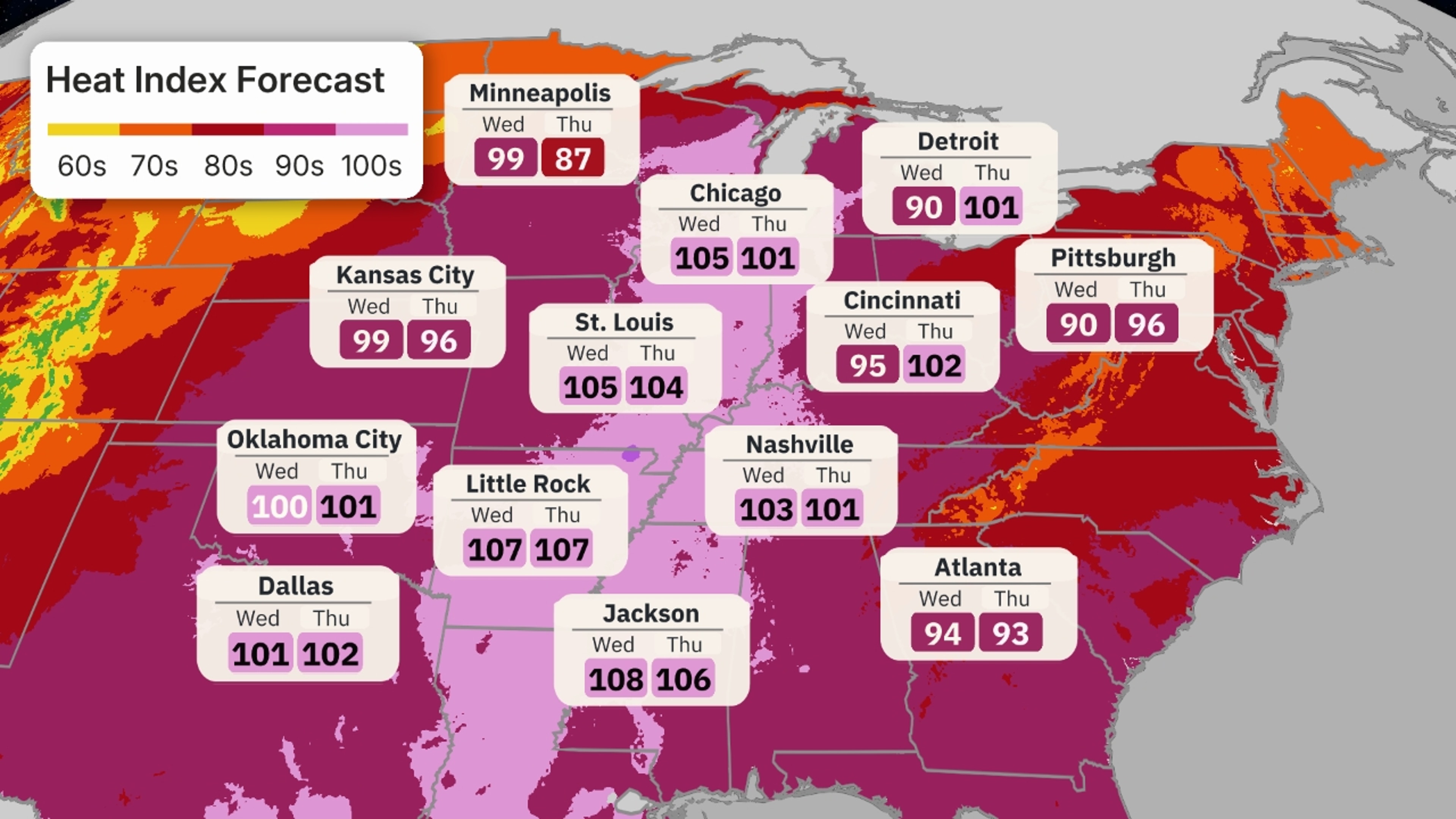
-But that doesn’t mean it won’t be dangerously hot. By mid-week, 90s will have spread from the South into the Midwest and Great Lakes. Parts of northern Texas, Arkansas and northern Louisiana will have highs peak at near or above 100 degrees.
-For a much larger area of the South, Midwest and Great Lakes, the heat index will top 100 degrees, including Chicago on Wednesday and Thursday.
-By late in the week, highs in the mid-90s will spread into the Northeast from Boston to New York City and Washington, D.C. The heat index will be near triple digits in these locations as well.
-And overnight lows in the middle to upper 70s will become increasingly common as the heat wave builds. That won’t allow much heat relief at night for those without access to air conditioning. Overnight low temperatures in some cases could be record warm in parts of the South, Midwest and East through the weekend.
(MAPS: 10-Day US Forecast Highs and Lows)
Stifling Humidity, Too
– This heat will be accompanied by oppressively muggy air particularly in the Mississippi and Ohio Valleys.
– Some dew points in these areas could rise into the upper 70s or even low 80s, about the muggiest air can get in these areas in summer.
– Some muggy air (70s dew points) will also be pulled north into the upper Midwest and Northeast, at times.
(MORE: What The Dew Point Means)
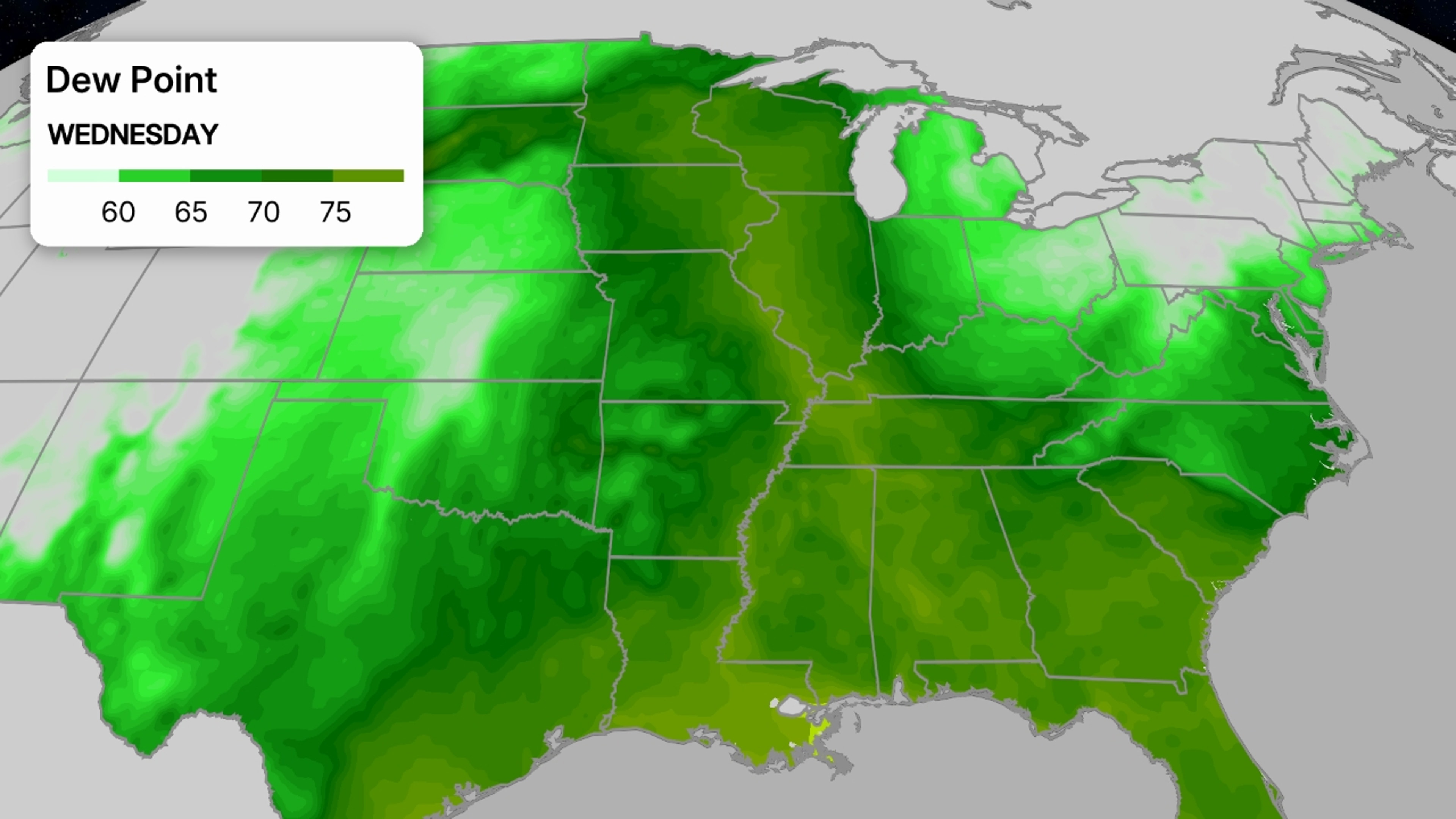
Forecast Dew Point
How Long Will This Last?
– Unfortunately, this heat wave may have staying power into at least the last weekend of July in the Plains and South, while slowly expanding west toward the Rockies.
– Our longer range outlooks suggest the Northeast has the best chance of eventually seeing some heat relief around that last weekend of July.
(MORE: Should You Turn Off Your A/C Or Leave It On When You Leave Home?)
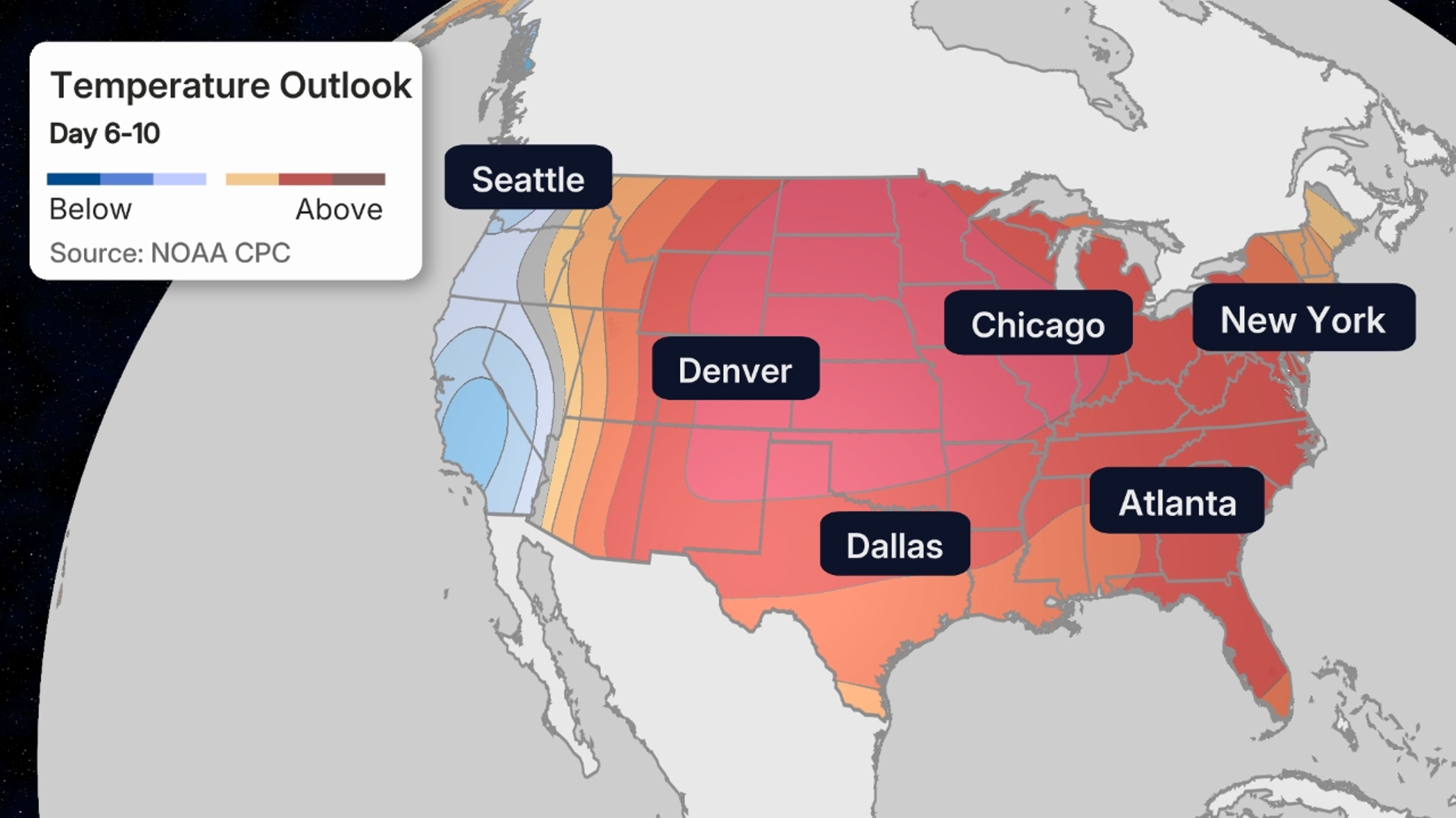
Long Range Temperature Outlook
What You Should Do
– Heat is the No. 1 weather killer in the U.S., with hundreds of fatalities each year.
– The combination of heat and humidity lingering into the night for several days in a row is dangerous for those without access to air conditioning, especially in the cores of larger cities.
– Check on family, friends, the elderly and those with chronic illness who live without access to air conditioning.
– If possible, avoid being outdoors for long in the peak heat of the afternoon.
– If not, take frequent breaks, avoid strenuous activity, drink more water than usual and wear loose, lightweight clothing.
(MORE: Heat Advice From An ER Doctor)
Why So Hot?
– A strong bubble of high pressure aloft known as a heat dome is developing.
– Sinking air near the center of this heat dome suppresses clouds, allowing the intense sunshine this time of year to heat the ground and air above it most efficiently.
– Southerly winds on the western periphery of the heat dome pull increasingly hot and humid air north, then may circulate that oppressive air eastward on its northern rim, sometimes fueling clusters of thunderstorms with flooding rain and/or high winds.
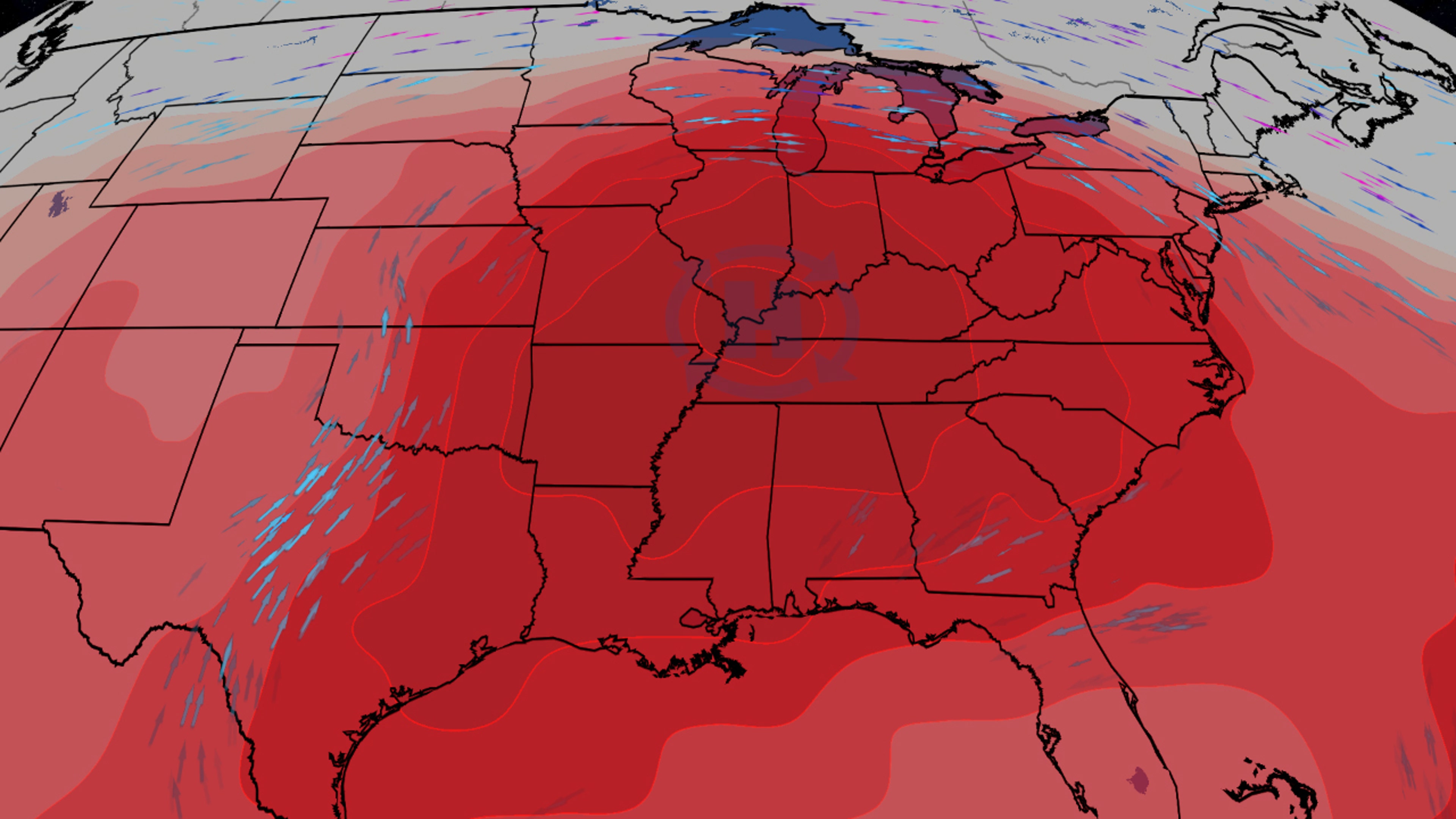
The forecast upper-level weather pattern shows a heat dome of high pressure over the Mississippi Valley responsible for the heat wave.
Jonathan Erdman is a senior meteorologist at weather.com and has been covering national and international weather since 1996. Extreme and bizarre weather are his favorite topics. Reach out to him on Bluesky, X (formerly Twitter) and Facebook.