
The weekend is kicking off on a stormy note across the Upper Midwest with severe thunderstorms and flash flooding a risk across several metro areas, including Chicago and Detroit.
DES MOINES, Iowa – The FOX Forecast Center is monitoring a large swath of the Midwest and Great Lakes region for the potential development of severe thunderstorms to kick off the weekend, with damaging winds, hail and even a few tornadoes as a mesoscale convective system develops and works east-southeast.
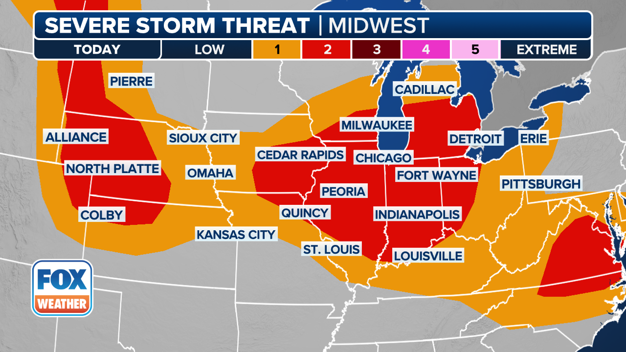
NOAA’s Storm Prediction Center has placed several states under a Level 2 of 5 risk for severe storms – a designation that could be upgraded if meteorologists see a larger severe weather outbreak on the horizon. Major metro areas including Chicago, Milwaukee, Detroit and Indianapolis are within this threat zone.
(FOX Weather)
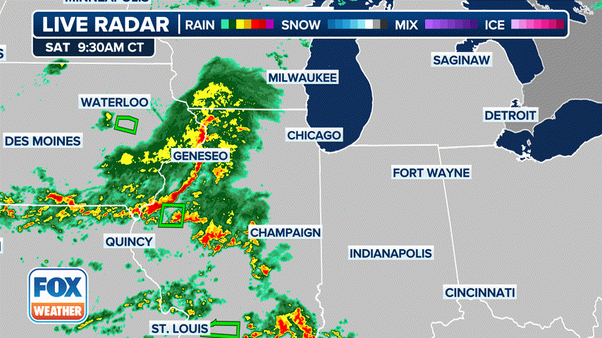
Severe thunderstorms were already rumbling in the predawn hours across Iowa on Saturday morning and were advancing eastward, putting cities including Chicago, Milwaukee and Indianapolis in the potential path later in the day.
A key question, forecasters say, is how long the storm complex can sustain itself, with communities closer to the initial development point expected to face the greatest risk.
(FOX Weather)
WHAT IS A MESOSCALE CONVECTIVE SYSTEM?
The Fox Forecast Center said the evolution of the storms will depend on how the MCS develops and moves.
While some communities, especially on the eastern end of the threat zone, may miss out on the complex of organized storms, enough instability will likely be untapped for additional scattered showers and thunderstorms to develop down the line.

Severe weather blew through central Iowa Saturday morning, triggering Tornado Warnings.
This would likely involve cities such as Detroit, Erie, Cleveland and Fort Wayne.
The later storms would mainly bring heavy rain and be more isolated, as opposed to the more organized, damaging complex of storms expected earlier during the day.
Forecasters advised residents in the risk area to monitor the weather outlook closely, as precautions such as staying away from windows and seeking a substantial structure may be necessary ahead of the stronger storms.
Two other areas of severe weather threaten Plains, mid-Atlantic
In addition to the Upper Midwest and Great Lakes, two other swaths of the nation are under threat of severe weather to kick off the weekend.
Farther west, a line of potentially strong thunderstorms stretches from eastern Montana, through the western Dakotas and into western Nebraska. While damaging wind gusts and a few isolated tornadoes are possible, the most significant threat is large hail – of baseball size or even larger.
The large hail threat zone covers cities such as Rapid City, South Dakota; North Platte, Nebraska and Sturgis, South Dakota.
(FOX Weather)
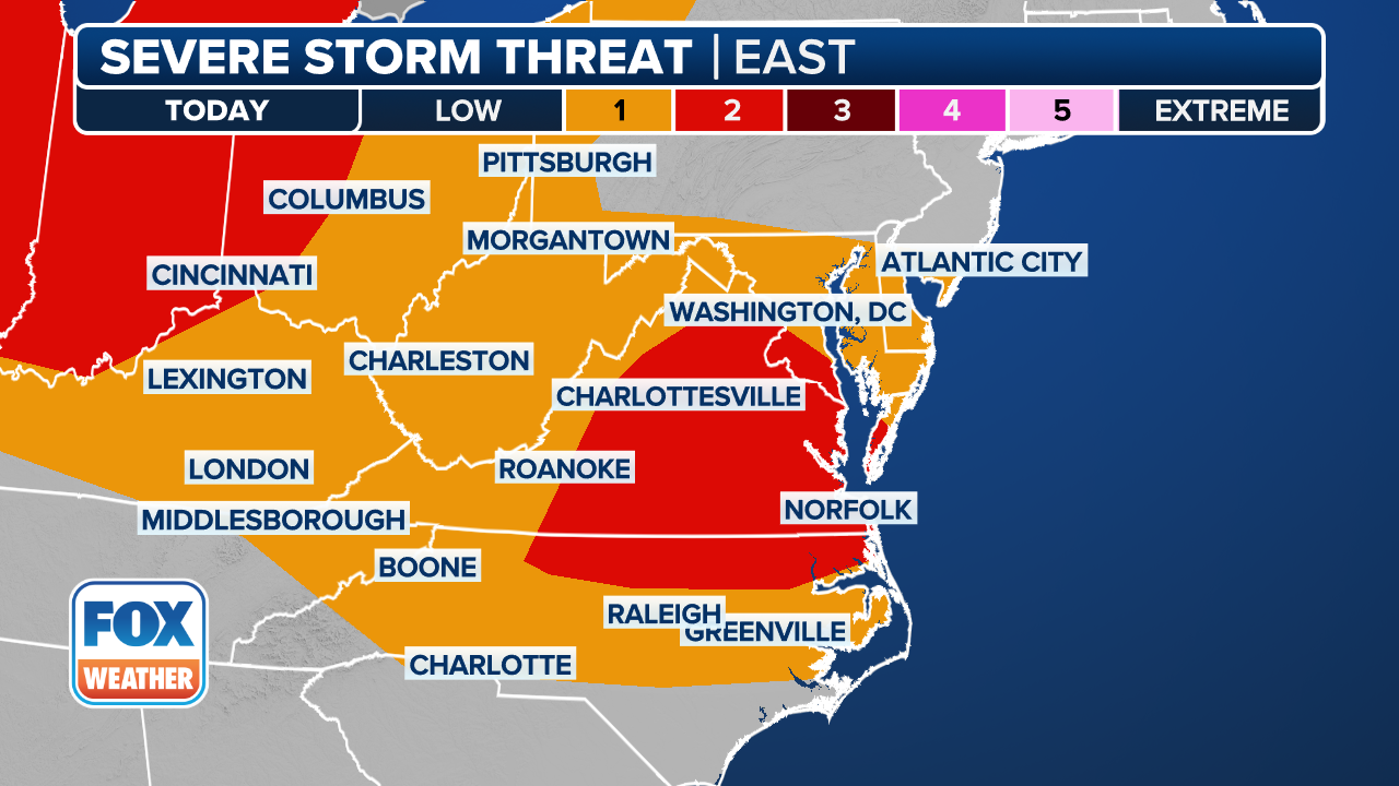
Along the Eastern Seaboard, the Storm Prediction Center has highlighted a swath of Virginia and northern North Carolina for potentially damaging winds amid severe thunderstorms Saturday. The risk zone includes Richmond and the Norfolk/Hampton Roads area.
Flash flooding risk covers several states in the East
Even if the storms don’t bring damaging winds or hail, they will contain plenty of rain, with a widespread threat of flash flooding covering much of the Ohio and Tennessee valleys into the mid-Atlantic and even parts of the Mississippi Valley.
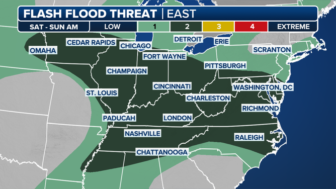
NOAA’s Weather Prediction Center issued a level 2 out of 4 risk for Flash Flooding stretching from Iowa to the Atlantic Coast.